


Kola Contested: Early Modern Russo-Danish Sovereignty in the Arctic
- Peripheral Histories ISSN 2755-368X
- Dec 14, 2021
- 7 min read

Earl Joshua Hodil
Maps are invaluable instruments in the historian’s toolbox, offering visual representations of historical phenomena. For those who wish to understand contested peripheries, such cartographical evidence is particularly rich in grasping opposing claims to territory, resources, and people. In the case of early modern Northern Europe, maps presented rivalling notions of sovereignty in the Arctic frontier between Muscovite Russia and Denmark-Norway. One in particular, crafted by Simon van Salingen, a Dutchman in service to Christian IV of Denmark, offers a perfect snapshot of this disagreement at the turn of the seventeenth century.


You can fully explore Simon van Salingen’s map of the Kola Peninsula here.
It was originally published in Axel Anthon Bjørnbo and Carl Petersen, Anecdota Cartographica Septentrionalia (Copenhagen: Societatis Regiae Scientiarum Danicae, 1908). The original map is housed in the Swedish National Archive (Riksarkivet) in Stockholm, Manuskriptsamlingen. Vol. 223: Diverse manuscript från 16-, 17-, och1800talen.Fol.21r-26v.
Throughout the late sixteenth and early seventeenth centuries, Moscow competed with Copenhagen for dominion over the Kola Peninsula (consisting roughly of modern Murmanskaia Oblast’). The two states based their claims on territorial rights inherited from defunct political entities now under their control. For the tsars of Russia, Kola fell under the rule of the medieval Novgorodian Republic, the lands of which Moscow had absorbed during the “gathering of the lands of Rus’” in the late fifteenth and early sixteenth centuries.[1] To the Danes, this region, to which they referred as Lapland, belonged to the Kingdom of Norway. Though Denmark and Norway technically existed in a union of the crowns, in reality the latter fell under the ever-tightening grip of the former throughout the early modern period.
Neither Russia nor Denmark, however, pushed their claims on the Kola Peninsula until the 1550s. Prior to this point, both states (along with a third would-be Arctic power, Sweden) functionally shared the tax revenue from the region, drawn from the indigenous Sámi population. Carsten Pape, through a careful examination of several late medieval and early modern Russo-Danish treaties, noted the existence of a dual border regime in the Arctic, including overlapping boundaries of taxation and at least a notional recognition of a hard border between the realms.[2] The impetus to define this state border more precisely, however, came in the latter half of the sixteenth century. In this region and in this period, Russia and Denmark conformed to Maier’s concept of the “space of states” which, in contrast to the “chronic unrest at the periphery” experienced by empires, seeks “frontiers stabilized by treaty.”[3] Though the potential for conflict between these states certainly existed, they primarily sought to resolve their disputes through the peaceful and treaty-bound delineation of their shared boundary. In doing so they participated in a broader process of the clarification of political space and sovereign boundaries in the early modern period.[4]
Tensions in the Kola Peninsula arose after 1550 for reasons both economic and geostrategic. This period witnessed both the rise of the White Sea Trade between Russia and various European states (notably England and the Dutch Republic) and the drive by Sweden to forge an outlet to the Arctic. These conditions likely pushed first Frederik II, then Christian IV, to make the first serious Danish claims on the Kola Peninsula. The acquisition of this territory could both thwart their perennial Swedish foes from breaking out of Denmark’s Baltic encirclement to the north and allow Copenhagen to levy a toll on the White Sea Trade (as they did for Baltic trade in the Øresund). The containment of Sweden, in the Arctic and elsewhere, formed arguably the most important goal of Denmark’s early modern foreign policy. The control of the new Arctic trade ensured that any revenues lost from the Sound Toll on this route remained in Danish hands (specifically those of the king, as this was a royal prerogative).
From the Muscovite perspective, this claim must have seemed absurd. Whatever Denmark’s justifications, since the medieval era Russians had settled in the Kola Peninsula, bringing with them the Orthodox faith among the Sámi. Though the Russian presence in the region in the late sixteenth century remained light, it far outstripped the utter absence of Danes and Danish institutions in Kola. Copenhagen’s threat also prompted the tsars to assert their sovereignty more forcefully in this territory, building up the fortress of Kol’skii Ostrog (near present day Murmansk) and dispatching a voevoda [provincial military governor] there to administer the region. Simon van Salingen himself expressed surprise at the rapid growth of this Russian outpost between the 1560s and 1590s in a 1591 report to Christian IV.[5] The development of Kol’skii Ostrog mirrored the construction of boundary defenses across the Muscovite realm at the turn of the seventeenth century, from the steppe to the border with Poland-Lithuania. It also occurred in the context of the tsars’ efforts to defend (and project) their sovereignty all along their northwestern reaches during the Livonian War (1558-83) and multiple conflicts with Sweden. The buildup of Muscovite infrastructure in Kola, however, failed to deter the Danes in this region.
By 1600, the young Danish king continued to press his claims to “Lapland”, dispatching a series of diplomatic missions to Moscow to achieve his goal. Though he briefly considered the practicality of seizing the Kola Peninsula while Russia suffered during the Time of Troubles (1598-1613), Christian almost exclusively relied on persuasion to gain his ends.[6] The Danes perhaps came closest to success in 1602-3, when Duke Johan of Schleswig and Holstein, Christian’s youngest brother, traveled to Russia to wed Ksenia Godunova, the daughter of Tsar Boris Godunov. Though Johan’s untimely death in Moscow prevented negotiations on Kola from moving forward, Boris at least seemed more receptive than before to the arguments of the embassy which accompanied him. In the end, however, the tsar remained unpersuaded and the Kola Peninsula stayed in Russian hands.[7] Despite sporadic Danish attempts throughout the remainder of the early modern period to rearrange the border to their advantage, the actual boundary between the two states would not be settled until the nineteenth century (after Norway entered a union with Sweden).
Frederik and Christian employed a plethora of historical evidence to assert their claims in the face of Russian opposition, from the writings of earlier historians to the names commonly used for geographical points around the Kola Peninsula. To this latter point, the Danes focused on the Russian practice of referring to the White Sea as the “Mourman Sea”, Mourman having been derived from “Norman” or “Northman” (i.e. Norwegian). For Copenhagen, this naming convention served as justification enough that the territory lying north of the “Mourman Sea”, the Kola Peninsula, was indeed “Lapland”, a territory claimed from time immemorial by Norwegian kings dating back to the Viking age.
To bolster this evidence, both Danish kings dispatched fact-finding missions to Kola. Frederik sought to map out the location and depths of various anchorages and ports along the peninsula’s coast, as well as the frequency and origin of shipping there.[8] Christian took van Salingen, who was familiar with the region, into his service to map out “Lapland” in order to precisely delineate Danish claims. It is van Salingen’s map that Christian sent with his brother to Moscow in 1602 to stake out his Arctic dominions, in hopes that the dynastic union would at last see this dream fulfilled.
The van Salingen map provided perhaps the most detailed image of the Kola Peninsula to date at the beginning of the seventeenth century and is replete with terminology and visual imagery pressing Denmark’s rights to the region.


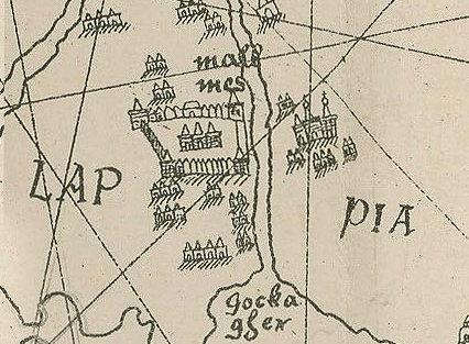


As you can see from the above images, the whole of the Kola peninsula is labeled “Lappia pars Norwegia”, indicating that it belonged to the king of Norway, Christian IV. Danish claims extended to the waters around Kola as well, with the northern half of the White Sea named the “Mourmanska more”. Though the Danes employed a transliterated version of the Russian name in this instance, the claim to maritime sovereignty is bolstered on this map by the placement of the royal arms of Norway at the heart of this body of water.
Interestingly, the van Salingen map appears to extend Christian IV’s ambitions even beyond the Kola Peninsula. A seal bearing the Danish king’s motto (“Regna firmat pietas”) is depicted in the Barents Sea north of present-day Arkhangelsk. A variation of Christian’s coat of arms is also placed in the Mezen River Basin in northern Russia, just under the label “Bermelandt” (see below). This latter geographical notation doubtless refers to the Scandinavian notion of Bjarmaland. The precise location of this land, referred to in Norse sagas, remains a topic of debate, but likely lay somewhere in the arctic regions of modern Russia. Bjarmaland was the subject of raids by Norse kings and it seems that Christian IV may have, in his role as the king of Norway, pressed a nebulous claim to this territory as well.[9] Given their inability to force their sovereignty successfully in Kola, the push for this “Bermelandt” may seem fanciful, but during the Time of Troubles both the Danes and the English considered plans to conquer parts of northern Russia. Returning to van Salingen’s map, it is telling that the label “Russia Pars” exists only south of this so-declared “Bermelandt.”

Though the Danish claims evident on van Salingen’s map never came to fruition, the Dutchman’s work perfectly illustrates the growing contest of sovereignty between Russia and Denmark on their far-flung Arctic border. The growth of new economic and geostrategic considerations in the early modern era forced both states to reevaluate their previously lax policies regarding this region. For the indigenous Sámi, sadly, this struggle rarely took them into account beyond their value as taxable populations and convertible souls. Maps, such as van Salingen’s, provide crucial visual context for written sources. They allow historians to understand the physical order of the world as viewed in the past. They also often make it possible to pinpoint historical locations the names of which have changed over the centuries. Finally, in the case of Christian IV’s imaginative interpretation of his realm’s territorial reach, maps offer a relatively subtle medium through which to stake claims of sovereignty.
Earl Joshua Hodil received his PhD from Yale University in 2020 with a dissertation titled "Three Royal Marriage Projects: Russo-Danish Relations in the Seventeenth Century." He is currently editing this project into a book manuscript for publication. He currently holds the position of Lecturer at Northern Arizona University where he teaches classes in world, European, and Russian history and serves as the faculty advisor for the History Club.
[1] Andreas Kappeler, The Russian Empire: A Multiethnic History, trans. Alfred Clayton (London: Routledge, 2001), 19. [2] Carsten Pape, “Rethinking the Medieval Russian-Norwegian Border,” Jahrbücher für Geschichte Osteuropas, Neue Folge, 52, no. 2 (2004): 161-87. [3] Charles S. Maier, Once Within Borders: Territories of Power, Wealth, and Belonging since 1500 (Cambridge: The Belknap Press of Harvard University, 2016), 15. [4] Ibid, 80. [5] See “Simon v. Salingens Bericht von der Landschafft Lappia” in D. Anton Friedrich Büsching, Büschings Magazin, Vol. VII, (Halle: Johan Jakob Curt, 1773): 339-46. [6] Kristian Erslev, ed., Aktstykker og Oplysninger til Rigsraadets og Stændermødernes Historie i Kristian IV’s Tid, Første Hæfte (Copenhagen: Nielsen & Lydiche, 1883), 139. [7] For a detailed analysis of the Ksenia-Johan marriage project, see: Earl Joshua Hodil, “Three Royal Marriage Projects: Russo-Danish Relations in the Seventeenth Century,” PhD diss., (Yale University, 2020). [8] Rigsarkivet (Copenhagen), Danske Kancelli, Sjællandske registre, No. 12 (1579-88), “Instructs som Erick Munk…” (1582), 231-233o. [9] On the Norse-Russian conflict in Bjarmaland, see: T.N. Jackson, Eastern Europe in Icelandic Sagas (Leeds: Arc Humanities Press, 2019).


